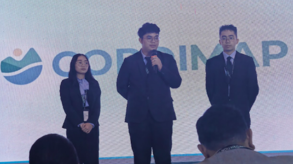
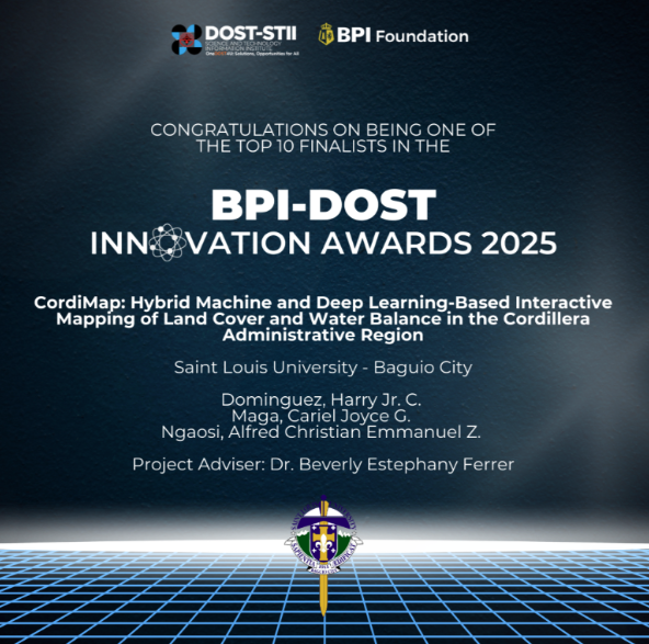
A group of 4th-year Bachelor of Science in Information Technology (BSIT) students from the School of Accountancy, Management, Computing and Information Studies (SAMCIS) has earned a prestigious Top 10 finalist spot in the BPI-DOST Innovation Awards 2025 held on 4 December 2025 at the Edsa Shangri-La, Manila, Philippines for their groundbreaking project, Cordimap: Hybrid Machine and Deep Learning-Based Web Application for Interactive Mapping of Land Cover and Water Balance in the Cordillera Administrative Region (CAR).
Guided by their adviser, Beverly Estephany P. Ferrer, DIT developed an innovative web application that uses machine learning (ML) and deep learning (DL) technologies to tackle urgent environmental challenges in the Cordillera Administrative Region (CAR). This ecologically sensitive area in Northern Luzon faces critical issues such as deforestation, urbanization, and the impacts of climate change, including unpredictable weather patterns, water shortages, and land degradation.
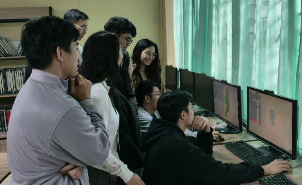
Cordimap integrates U-Net deep learning architecture to classify land cover using Sentinel-2 satellite imagery and employs XGBoost time-series forecasting to predict water balance trends. The platform provides a real-time, interactive map that allows local governments and stakeholders to monitor environmental changes, plan for water resource management, and make data-driven decisions on land use. This system is not only crucial for addressing climate change and biodiversity loss but also supports disaster preparedness and resilience planning, key components for sustainable development in rapidly changing regions.
By offering detailed insights into land use and water availability, Cordimap empowers communities and authorities to protect natural resources and create policies that promote sustainable urbanization and ecosystem conservation. This project offers a scalable solution for regions across the Philippines and beyond that face similar environmental challenges.
The success of the Cordimap team at the BPI-DOST Innovation Awards 2025 highlights the potential of young innovators to drive meaningful change in both technology and environmental management. Their project not only exemplifies the power of data science to solve real-world problems but also reinforces Saint Louis University’s commitment to developing leaders who can create solutions for a more sustainable and resilient future.
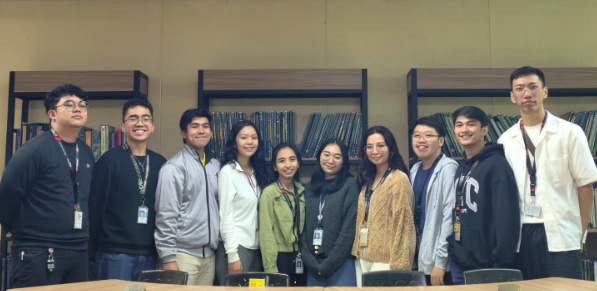
Congratulations to the Saint Louis University BSIT students, Sean Justin Aromin, Nikko Andrei Choy, Harry Dominguez Jr., Ma. Earl Freskkie Encarnacion, Cazandra Jae Lapig, Donna Liza Luis, Cariel Joyce Maga, Alfred Christian Emmanuel Ngaosi, Judrey Padsuyan, Eugene Kyle Patano, Jhea Jhana Prudencio, and Dr. Ferrer for this outstanding achievement. Their work is a prime example of how innovative technology can address environmental issues, offering a brighter future for both local communities and the planet. (Article by Kasima Rose M. Mendoza | Photos by SAMCIS)
Project Summary
Cordimap: Hybrid Machine and Deep Learning-Based Web Application for Interactive Mapping of Land Cover and Water Balance in the Cordillera Administrative Region
Project Adviser: Dr. Beverly Estephany P. Ferrer, DIT
The Cordillera Administrative Region (CAR) is a critical ecological zone in Northern Luzon, facing increasing environmental pressures due to urbanization, climate change, and deforestation. These result in decreased green spaces and impassable land surfaces, leading to a high risk of natural hazards. Additionally, climate change increases evapotranspiration, variability of rainfall patterns, and the frequency of droughts and water shortages. There exists a need for a system that supports sustainable land and water resource management.Cordimap is a hybrid, machine-learning and deep-learning-based web application for land cover classification and water balance forecasting in CAR, enhancing data-driven environmental planning and resource management. Cordimap integrates a U-Net architecture-based deep learning model that utilizes Sentinel-2 L2A satellite imagery for land cover classification, and an XGBoost time series forecasting model that leverages ESRI water balance data to predict water balance trends.

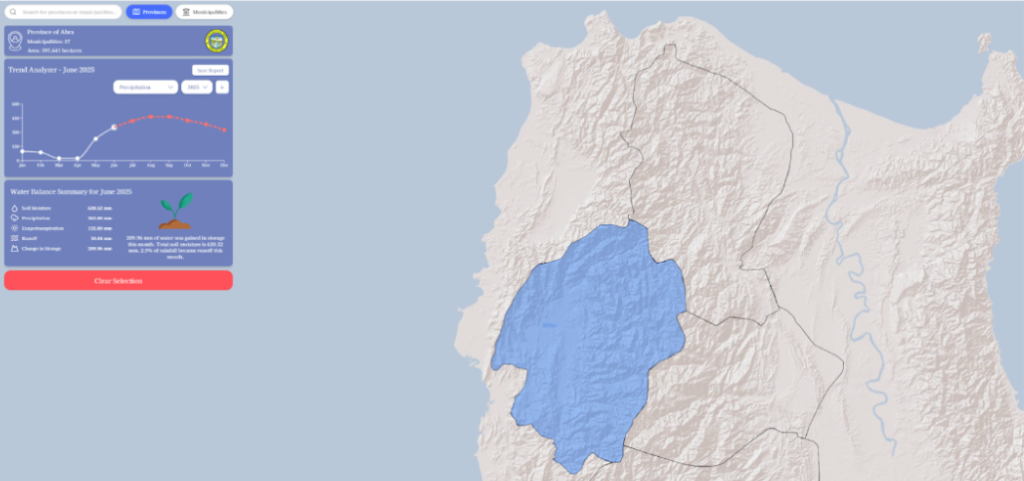
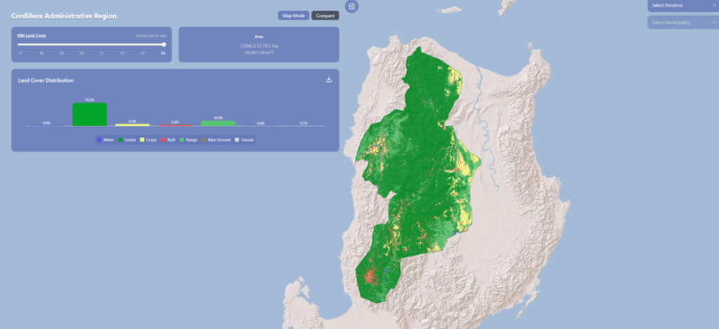
Through the application’s ability to forecast water balance and visualize land cover for monitoring land use in provinces and municipalities, using accurate political boundaries, it can help government agencies in decision-making and creating policies for resource management and disaster preparedness. This system also supports the achievement of the UN Sustainable Development Goals (SDGs), particularly SDG 11, Sustainable Cities and Communities, and SDG 15, Life on Land, as it enables a deeper understanding and more effective monitoring and management of environmental challenges associated with urbanization, deforestation, and climate change.